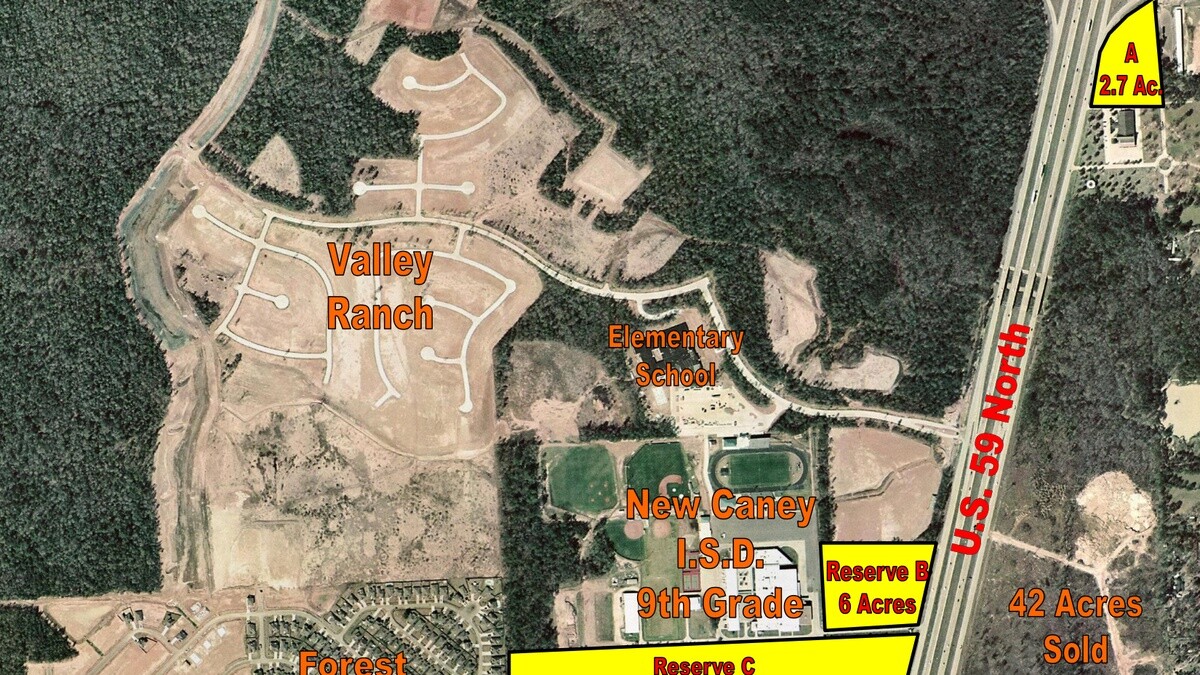
Buying raw commercial pad sites or retail reserve acreage along a fast-growing highway corridor like US-59 North in Northeast Houston is a civil engineering exercise before it is a real estate play. Two tracts sitting side by side on the same freeway feeder road can have completely different development costs depending on Municipal Utility District water and sewer capacity, floodplain elevation, and where TxDOT will legally allow a commercial deceleration lane and curb cut.
We performed the pre-acquisition civil engineering and land development feasibility audit on this commercial reserve tract. We verified water and sanitary sewer trunk-line capacities with the utility district, analyzed regional stormwater detention allocations so the buyer wouldn't have to burn thirty percent of their pad site digging a dirt pond, and evaluated highway frontage geometry against TxDOT access management rules.
Technical Specifications & Commercial Land Civil Engineering Scope
Developing commercial retail pad reserves along a major highway corridor requires coordinated multi-trade engineering analysis across civil, environmental, and transportation systems:
- Civil Site Topography & Stormwater Drainage Outfalls: We audited site topographic elevation surveys, mapped natural drainage swales, and calculated stormwater detention basin requirements to meet Montgomery County drainage criteria. We evaluated downstream drainage outfall easements to ensure runoff from future commercial parking lots could discharge without flooding adjacent parcels.
- TxDOT Highway Frontage & Ingress/Egress Permitting: We analyzed frontage rights along US-59 and regional feeder roads. We evaluated line-of-sight safety distances, deceleration lane requirements, and coordinated feasibility reviews with Texas Department of Transportation engineers to verify permitted commercial curb-cut locations.
- Municipal Utility District (MUD) Water & Sanitary Sewer Capacity: We audited local municipal utility district infrastructure plans. We verified the proximity and sizing of regional water distribution mains, sanitary sewer trunk lines, and evaluated required capital impact fees to reserve water and sewer capacity for retail shopping center buildouts.
- Phase I Environmental Site Assessment (ESA) Review: We reviewed historical land use records, aerial photography, and local regulatory databases to confirm the absence of recognized environmental conditions (RECs), historical agricultural chemical storage, or underground petroleum pipeline leaks across the tract.
- Subsurface Soil Geotechnical Suitability: We reviewed preliminary soil boring logs to determine soil plasticity, groundwater table depths, and subgrade load-bearing capacity for future commercial slab-on-grade foundations and heavy concrete parking fields.
Field Execution, Permitting & Code Realities
Navigating commercial land development in Montgomery County requires reconciling municipal utility district regulations, county engineer drainage rules, and state environmental standards.
Our civil underwriting team coordinated detailed retail pad subdivision scenarios. We structured commercial parcel platting models that maximized high-value highway frontage pads for quick-service restaurants, retail fuel stations, and convenience retail, while preserving back acreage for commercial storage or light industrial trade facilities.
Wetland delineation and flood plain compliance formed another critical operational milestone. We cross-referenced FEMA flood insurance rate maps (FIRMs) and consulted with civil hydrologists to verify that proposed commercial building pads sat entirely above the 100-year base flood elevation, eliminating mandatory federal flood insurance requirements for future retail building owners.
Underwriting Discipline & Physical Plant Control
Commercial land acquisitions carry high financial carrying costs where infrastructure delays or utility moratoriums can trap developer capital for years. Disciplined pre-acquisition feasibility due diligence delivers vital investor safeguards:
- Verification of Highway Access Feasibility: Securing verified TxDOT driveway approval parameters before closing prevents buyers from acquiring landlocked or restricted frontage tracts that cannot support retail traffic.
- Guaranteed Utility Capacity Commitments: Confirming MUD water and sanitary sewer availability protects developers from multi-hundred-thousand-dollar off-site utility extension costs.
- Accurate Civil Infrastructure Budgeting: Calculating exact stormwater detention basin acreage and earthwork fill volumes ensures developers reserve sufficient land and capital for site civil engineering.
- Optimized Retail Pad Parcelation: Structuring pre-planned pad subdivisions accelerates parcel carve-out sales to national retail and dining operators, rapidly recapturing initial land acquisition equity.
The Ground Truth
Land developers lose money when they pay retail pad prices for acreage that secretly requires six figures of off-site utility extensions or an on-site detention pond that eats up half the buildable parking field. Once you close on raw land without utility commitments and access verification, your timeline belongs to the engineers and regulators.
Verifying off-site detention allocations, utility tap availability, and highway curb-cut geometry during feasibility gave the buyer the hard civil facts needed to map out pad subdivisions and underwrite vertical site work down to the dollar.